HerdProof Browser workspace

Drone-assisted livestock review for agricultural lending. Check cattle observations and survey evidence, then explore the field behind a loan application.

Why I built HerdProof

I built HerdProof to explore how drone imagery could support livestock monitoring for agricultural lenders. It brings cattle observations, photo consistency checks and field context into a reviewable record, so a reviewer can see what needs closer inspection.

Agricultural industrialization starts with repeatable ways to inspect productive assets. The next step is to test whether this workflow reduces review work in a real lender pilot.

Upload photos and draw at least three boundary corners.

Field context from near-vertical DJI photos in France. Measured elevation; approximate photo alignment and cow appearance.

Farm map

Trace the field.
Check the photos that claim it.

One boundary can span many photographs. Start from the map, or start from your survey.

IGN reference orthophoto · approximate drone-photo overlay

Click at least three boundary corners, then choose Edit and pan. Drag vertices to adjust.

Farmland you claimPhoto coverage

Survey photos

None yet
Add the photos from your survey flight

Up to 24 JPEGs or PNGs, 20 MiB and 32 MP each. Overlapping photos can cover the whole farm.

Checks read the uploaded file itself. Missing GPS or time stays unknown.

Farmland boundary

Not saved
Draw a boundary to begin
Vertex coordinates and map source

Positions use EPSG:2154 metres. GeoJSON uses longitude, latitude. The example outline is illustrative; it establishes no cadastral ownership.

Map extent 500 × 500 m. Map: IGN, Licence Ouverte 2.0. Drone-photo alignment is approximate.

Declare and check

This is your assertion, in camera-local time. The checks hold it against the date the file itself carries. EXIF time and GPS are editable, not authenticated capture.

Save a boundary and choose a photo to run the checks.

FOR THE LIVESTOCK REVIEWER

Survey review summary

Awaiting evidence

Load survey photos and save a boundary to begin. Results here stay tied to the selected survey.

Next action

Load the demo batch or a survey, then check its photos.

Observations support human review. Total herd inventory, animal ownership and loan eligibility remain unverified.

The assessment appears here

  1. Load the demo batch to place six overlapping drone photos.
  2. Trace the farmland across them, or use the example outline, and save it.
  3. Check the photos for reused evidence and for date or location conflicts.

Photo coverage is not the farm boundary. Photos with missing camera metadata stay available for evidence checks.

Assessment history

Saved on this computer. Verification compares an export against the original server record.

No evidence submitted yet.

THE ENGINEERING

One cow can appear in several photos.

Download recorded results

The counting pipeline detects cows in the original photos, aligns overlapping backgrounds and compares observations in the area both cameras can see. A clipped cow can match a clearer view; an unresolved sighting stays flagged for another capture.

  1. Detect in each photo
  2. Align shared ground
  3. Remove repeated sightings
  4. Review uncertain observations
  5. Export evidence
RECORDED TWO-PHOTO RUN · 6 SEP 2026

From repeated sightings to a reviewable estimate.

Image detections
30
Repeats removed
12
Estimated distinct sightings
18

Next action: capture another view. One clipped sighting remains unresolved and is included in the estimate. The saved pipeline status is needs_edge_recapture.

Actual saved model output from two photos captured on 7 Nov 2023. This is a pipeline example, separate from the selected survey above. The 18 sightings have not been independently verified; full-property coverage is unverified.
What has been measured

Detector precision / recall
81.92% / 77.91%
Controlled overlap cases passed
192 / 192
Known duplicate links recovered
1,293 / 1,293

Detector: corrected YOLOv8n v2, confidence 0.70; 77 images and 1,041 provisional annotations. Exploratory results on a previously inspected public benchmark, with incomplete labels; not fresh blind validation.

Overlap: two 96-case crop suites using supplied annotation boxes and known identities. These test matching geometry separately from detector accuracy, moving-animal identity and whole-herd counting.

Explore the detector’s saved observations ↗
See matched observations across real drone photos
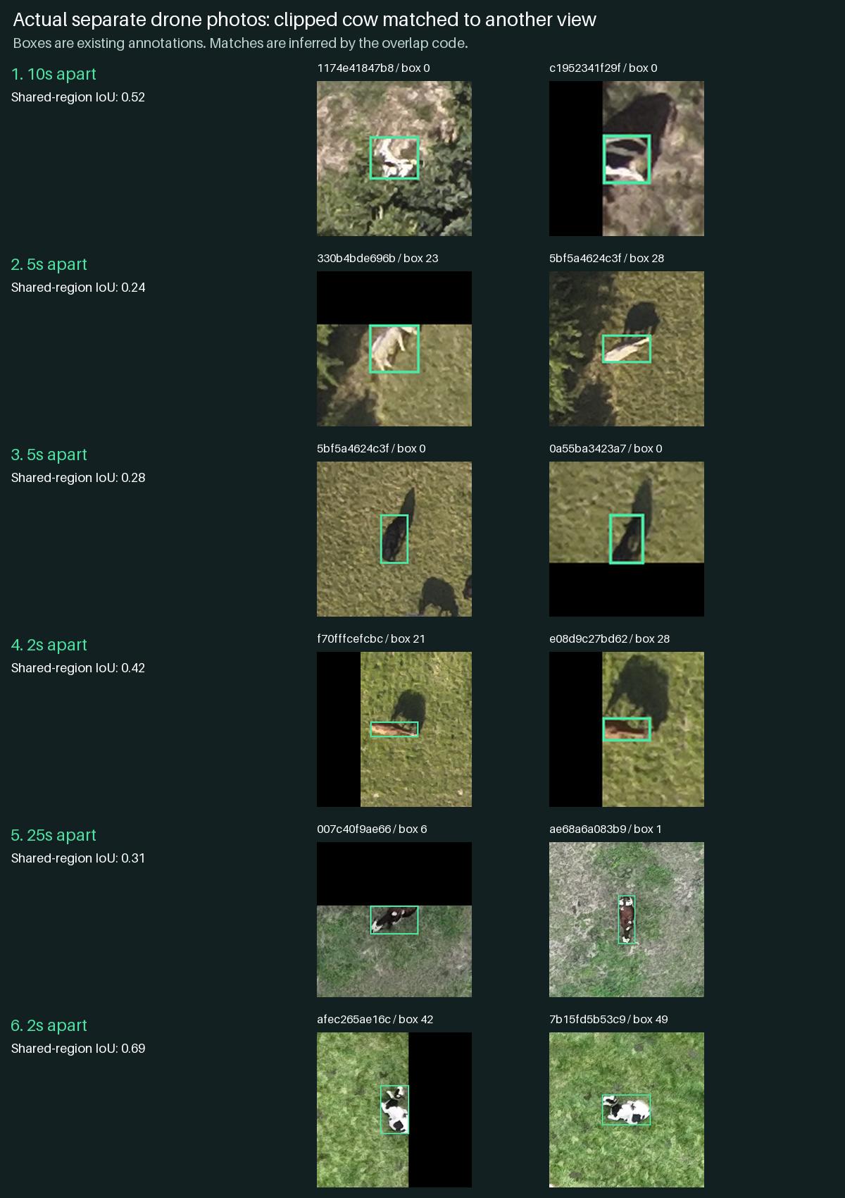
Six pairs of drone-photo crops show clipped cows matched with another view. Green boxes are source annotations; matches are inferred by the overlap code.
Existing annotation boxes, with matches inferred by the overlap code. Imagery: Helary and Lebreton / Institut de l’Élevage, ICAERUS grazing cows v2, CC BY 4.0. Dataset and attribution.
BEYOND THE PROTOTYPE

Start with one lender and one ranch.

Proposed pilot

The first intended user is an agricultural loan officer or livestock collateral reviewer. A ranch or inspection partner supplies a dated survey; the reviewer checks observations and exceptions, then attaches the exported assessment to an existing review process.

Fit the existing workflow

Begin with inventory monitoring alongside the lender’s current inspections and records. Human reviewers resolve discrepancies. Animal identity, ownership, valuation and lending decisions need separate evidence and policies.

Measure the full cost

Compare assisted and manual review on independently checked surveys. Measure missed cattle, corrections, recaptures and total review time, including capture, upload and processing. Cost per survey and willingness to pay remain to be measured.

Prepare for real farm data

This demo runs browser checks and displays a saved world. Deployment needs authenticated access, separation between customers, retention controls, secure storage and an agreed capture protocol. Validate local flight requirements and lender data policies before a pilot.

Pilot success: useful evidence with fewer review hours, without increasing missed cattle or hiding gaps. Savings and lender adoption have not yet been established.